
John’s e-mails tell me that Spring has returned
to the central Japanese high plains we inhabit.
“Yo Kev! Weather’s lookin sweet, bro! You up for a ride?”
His enthusiasm is infective. Not that it takes much to get me out on the bike.
He talks sometimes of mountain biking the trails of nearby Hachibuse-yama, though in his voice I hear more reminiscence than actual suggestion. That’s fine with me. I run those trails on occasion, and to me there's no better way to communicate with the gods who reside there than entering their world on foot.
Besides, one broken collarbone is enough.
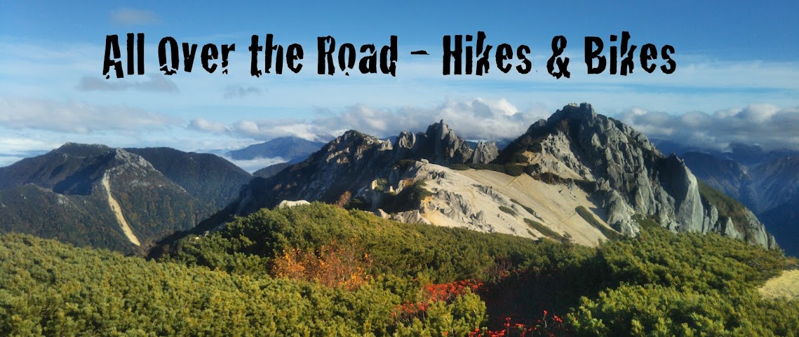
More often than not we end up heading for the Azumino-Yamabiko Cycling Road, a 15-kilometer path that arcs across the Azumino Basin, just north of Matsumoto. Out there, Japan’s Northern Alps run the length of the visible western horizon, towering over fields of rice and apple trees. To the east, the 2,000-meter Utsukushi-ga-hara highlands peek out from behind lesser ranges. In between, a loose web of old-growth neighborhoods lies strewn over a slice of earth that is as flat as it is quiet.

The path itself runs alongside a wide and lazy irrigation canal, a waterway that not only gave birth to this cycling road, but gave life to this once-intractable land.

Seafarers & Loose Soil
The area takes its name from the Azumi, a clan from the southwestern island of Kyushu whose religious beliefs and way of life were centered around the sea. After serving as the de facto naval force of the emerging Yamato imperial nation from the 3rd to the 7th Centuries they began migrating eastward. Inexplicably, some of them settled in this region, about as far from the sea as you can get.
The rainwater and snowmelt running off the western
mountains is pristine and plentiful. But Nature, in all her indifference, left
this land with few rivers. The ground here does not hold water as it does
further south. What flows down the canyons quickly disperses and disappears
into the soil, creating what is called in geological circles an alluvial fan,
which until an hour ago was what I thought a dancing geisha held in
her hand.
What rivers do run – the Karasu and the Kurosawa – are too meager and unreliable to sustain crops. With few options (moving somewhere else apparently not being one of them) the Azumi people established small villages and subsisted on fresh-water fishing.


In the early 17th Century several attempts were made to divert the waters of the Azusagawa running across the southern plain. But their efforts proved fruitless; each time the river rose the already-loose earth would get washed away. Skilled as the people living here became at digging irrigation ditches, they got pretty god damn tired of it.
But man is a stubborn creature. At the tail end of the 18th Century two men, Magoichiro Todoriki and Wahe-e Nakajima, began separately planning new irrigation systems. By the mid-19th Century the Jikka-segi was just one of several waterways in use, turning the Azumino Basin green and fertile and delighting the people, who were by now getting pretty sick of fish.

Taking In What Exists
On paper, one stretch of the Azumino-Yamabiko Cycling Road runs right through Matsumoto. In reality that part of the path does not yet exist. There’s no sign of it ever being built either.
“No problem!” yelled John over his shoulder as I chased him through the ever-busy Shiraita intersection, just northwest of downtown. “We’ll go the back way!” He took us down a side road that threw us into the woods and over a creek fed by an underground source of mountain runoff.

I knew nothing of the Azumi people or failed irrigation projects the first time I rode this path. I cared little about anything on my next dozen rides either except the mountains and the quietude and the pleasure of being out there on my bicycle under the sun. I didn’t know that creek in the woods flowed up from underground. I never even noticed that the Jikka-segi canal, so close to the bike path one could (theoretically) spit in it, suddenly disappeared near the yawning Azusagawa riverbed and miraculously reappeared on the other side.
But hey, you don’t need to know the history of this area or understand the mechanics of the waterways to enjoy the Azumino-Yamabiko Cycling Road. I am living proof of that. And yet these things are a part of the story of this land. And like the mountains and the serenity, they are both priceless and free.
A busted collarbone, on the other hand, is both free and costly. Ride safe, my friends.
Nerding Out on Two Wheels
On the other side of that creek the path leads to a road that runs along the Narai-gawa River. Sometimes there are cormorants, diving for fish or drying their wings in the sun. Occasionally I spot a snow-white heron. They are as skittish as they are beautiful; stop your bike two hundred yards away to try to take a picture and they'll fly away before you have a chance.

Under the tracks of the Oito Line and past Shimbashi Bridge and soon you come to the head of the Jikka-segi waterway. In Japan dams are as common as skittish birds, serving various and often multiple purposes. This one keeps the Narai-gawa from washing the nearby mountains away while feeding the Jikka-segi.

Riveting, I know. But stick with me. We're heading for greener lands.


Just past the Hirase-bashi Bridge (in the picture above, down the Narai-gawa River) the Jikka-segi turns west and disappears through Door #1.


...and it reappears through Door #2.

And in the age-old Japanese way, there's a memorial to the construction of the tunnel under the river. It consists of a piece of the digging machine.
It's nice.

A couple concrete tunnels and an industrial highway zone and the path rolls out into the Azumi Basin.


There are always a handful of people cycling, jogging and walking. At the Jikka-segi Cycle Hiroba Plaza, when the seasons are at their most colorful, you'll get modest crowds showing up in their cars to take in this one small slice of the trail.


Wander away from the path and you'll find a few more pockets of historical and cultural intrigue.


For everything this path and this area have to offer, the most amazing thing might be what is most easily overlooked.
For 15 kilometers the glassy, gentle waters of the Jikka-segi canal flow perfectly unimpeded. Remember that thing about the land here being flat? That's no figure of speech. From the beginning of this waterway to the end - over the course of nine miles, along a path that follows the almost imperceptible contours of the terrain - there is a vertical change of five meters. Five meters! Good grief, there are pool tables that aren't that flat. I should know, growing up I had one in my basement.

The bike path itself is not quite that level all the way. Here and there it ducks through underpasses and crosses over the water. But still, the Azumino-Yamabiko Cycling Road may be the smoothest, flattest fifteen kilometers this side of California's salt flats.
Let me know if you want to check it out. I'm always up for a ride. On the off-chance I'm busy try shooting John an e-mail.
No comments:
Post a Comment